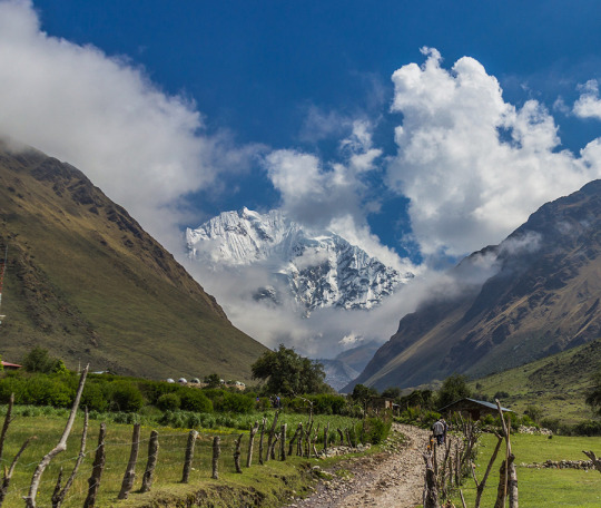
The snowy Salkantay (Wild Mountain), is one of the highest mountains in the Cusco region, along with the snowy Ausangate in the Vilcanota mountain range which is located further south, this snowy has two types of peaks, which years ago they had some differences between them, but today after the collapse of the Serac to the WEST of the snowy mountain, it shows that both tops are really identical. SALKANTAY TREK INFORMATION
The summit to the WEST is slimmer
While the summit located to the EAST, it is slightly higher when it is crowned by a SERAC (large block of ice fragmented by important cracks in a glacier).
During the way towards the snowy Salkantay, you will be able to witness the excellent flora, among it you will find the famous Orchids that are very beautiful and colorful adorning the landscape.
Location:
The snowy Salkantay or Salkantay is a snowy mountain in Peru, located in the Vilcabamba Mountain Range, in the Santa Teresa district, La Convencion province, Cusco Department. This beautiful snow-capped mountain rises to 6264 m. n. m.
The Incas covered much of the South American continent. To maintain communication in such a vast territory, it was necessary to build a network of roads. Thus, the Inca ordered to build a network of roads called Qhapac Ñan (Inca Trail).
The Qhapac Ñan managed to cover up to 30 thousand kilometers from the current countries of Peru, Ecuador and part of Bolivia, Chile, Argentina and Colombia. The trekking route from the Inca Trail to Machu Picchu is only a small part of the extensive network of roads of the Qhapac Ñan.
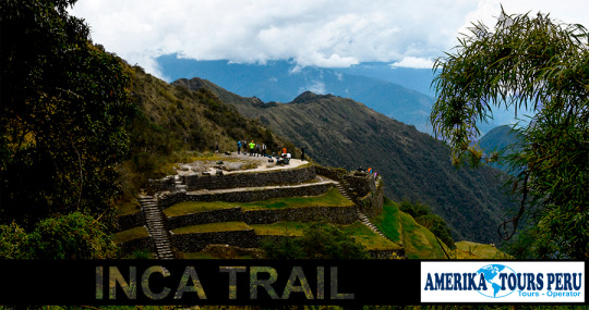
The Inca Trail to Machu Picchu
The Inca Trail was revealed to the world in 1915 when it was being excavated in the Inca City. Three decades later, the route was traced by the Viking expedition in 1942. Today, thousands of visitors decide to travel the 43 kilometers to the ‘Puerta del Sol’ in Machu Picchu.
However, Machu Picchu is not the only archaeological site that you will see on the Inca Trail. On the tour you will also appreciate the ruins of Llactapata, the archaeological site of Runkurakay, Saycamarca, Phuyupatamarca and Wiñaywayna.
There are trains and buses that can take you directly to Machu Picchu. However, the experience of arriving as the Incas did for centuries is unmatched.
Versions of the Inca Trail to Machu Picchu
Not all people have the necessary days to travel the Inca Trail (4 days and 3 nights). That is why there are 2 versions depending on the time you have:
Classic Inca Trail: 4 days and 3 nights (43 kilometers of walking).
Short Inca Trail: 2 days and 1 night (12 kilometer walk).
How is the tour of the Inca Trail to Machu Picchu?
The Inca Trail shows rugged geographies with ascents and descents next to cliffs. The mountains reach great heights with rugged stretches. In the jungle areas you will see the variety of shades of green tropical forests.
Day 1: Cusco – Wayllabamba (13 kilometers)
The Inca Trail begins at kilometer 82 of the railway that leads to Machu Picchu (2 hours and 30 minutes by bus from the city of Cusco). Then the ascent to the Cusichaca valley will begin. The visitor will visit the ruins of Llactapata (2,840 masl) until reaching the town of Huayllabamba (3,057 masl).
Day 2: Wayllabamba – Pacaymayo (11 kilometers)
The second day is the most difficult due to physical demand. The tourist will ascend to the Warmiwañuska (‘Dead Woman’s Pass’). This is the highest point of the route (4,215 masl). From this point it is possible to see the Runkurakay archaeological site (3,760 masl).
Day 3: Pacaymayo – Wiñay Huayna (16 kilometers)
The third day the descent will be dizzying to the Pacaymayo river valley. The section goes down a steep slope of almost 1,600 meters to the Sayaqmarca compound (3,625 masl). Here the view is extraordinary.
Day 4: Wiñay Huayna – Machu Picchu (3 kilometers)
The last day hides some of the best Inca samples: Phuyupatamarka, Wiñaywayna. Upon leaving these ruins, a gradual descent will be undertaken which will become more complicated in the end. Finally, you will arrive at Intipunku or Puerta del Sol. From there you will walk for another 30 minutes to the Lost City of the Incas, Machu Picchu.
After visiting Machu Picchu, the visitor returns to Cusco through a train and bus service. The duration of the trip is approximately 3 hours. These services are included in the tours to the Inca Trail.
During the 4 days of the Inca Trail you will experience fatigue and very low temperatures (between the Andes Mountains and the Amazon forests).
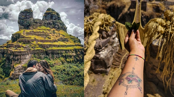
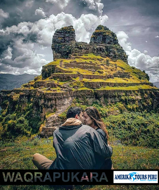
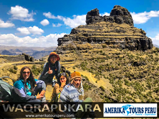
Waqrapukara Tour, is the archaeological monument located in Acos, Acomayo province in Cuzco, which has been declared a National Cultural Heritage by the Vice Minister of Cultural Property. This Inca monument is located on the slopes of Mount Kenter, has a privileged view of the Apurímac River and has two groups of buildings.
The first group is located at the top, in the middle of a rocky dam, where you can see two enclosures separated by a wide central space. The enclosures have halls, ornamental niches and doors with double jambs; its architecture seems to be similar to that of other ceremonial buildings.
The second enclosure is located at the bottom, and has 8 platforms 153 meters long and 1.80 meters high, which correspond to the topography of the terrain.
Some inhabitants of Acos also call it Llamapukara; and although its origins go back to pre-Inca times, its foundations were built by the Q’anchi, and the Inca construction was built during the sovereign period of the Tahuantinsuyo Wayna Qhapaq.
Waqrapukara: Hidden Trips to the Incas
However, the destination is gaining attention as a hidden gem for travelers seeking an alternative hiking and camping adventure.
Located in the Acomayo province, in the Pomacanchi district of Cusco, the name Waqrapukara means “horn-shaped fortress.”
Getting there involves a 2½-hour drive from Cusco to the town of Santa Lucía, and then a 2-hour walk.
Similar to Machu Picchu, the Inca ceremonial architecture at Waqrapukara combines the amazing stone masonry and spectacular natural formations.
Nestled sinuously along a rocky outcrop, built around two horn-shaped mountain peaks, the site features eight Inca terraces with retaining walls and stone staircases.
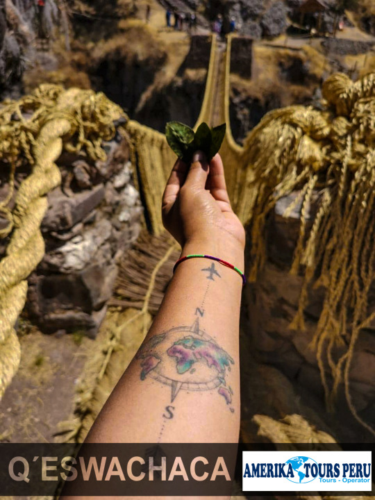
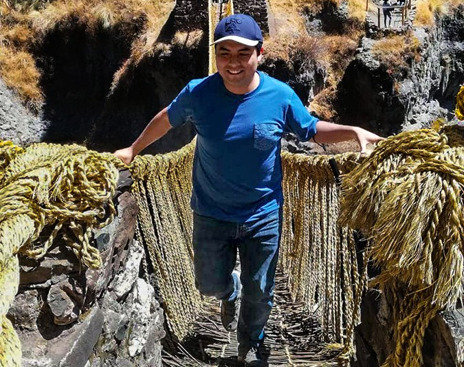
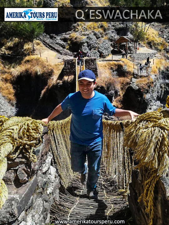
Qeswachaka Bridge Ritual
On the second Sunday of June, the Qeswachaka Bridge Reconstruction Festival is held in the town of Quehue.
Thanks to this tradition of Inca origin, the Qeswachaka suspension bridge has been maintained. This cooperative work is carried out by the communities of Huinchiri, Chaupibanda, Ccollana, Quehue and Pelcaro.
The renovation of the bridge is repeated year by year. The festival lasts 4 days and involves all the men and women of the towns involved.
informationAt dawn on the first day, the ‘Paqo’ (officiating the ceremony) celebrates the rite in favor of the te Apu tutelary Quinsallallawi ’. On the other hand, the ‘icchu’ (straw) was collected and stacked in advance by members of the 4 communities.The women of the communities who have the function of weaving the first soguilla or ‘qheswa’ actively participate in these activities.In the afternoon, the males divided into 2 groups gather over the sides of the bridges and spread the “queswas” in a straight line on the road.Finally the ropes are braided by the ‘Chakaruwac’ (Inca engineer) to assemble the ‘Qheswasca’ (major braid).Second dayOn the second day, the dismantling of the old ropes that support the bridge is carried out.Then we proceed to tie the new braids that will be thrown from one side of the bridge to the other for its assembly.In total 4 thick ropes are braided which serve as the base and railings for the bridge. The men who carry out this work have extensive experience and are respected by the rest of the community.Third dayThe third day continues with the assembly of the railings and the base of the bridge.Men must complete the work with great effort (and risk). According to Inca tradition, women should not cross or show themselves until the bridge has been installed. This due to the belief that women bring bad luck.After installing the Inca bridge of Qeswachaka, the inauguration proceeds with music, typical dances of the region, delicious typical dishes and alcoholic beverages.Fourth dayOn the fourth day (central day), the chakuruwacs finish weaving the bridge, securing the last fibers. Finally, a scream announces the end of the hard work.The last day there is a festival with typical dances of the region and sale of typical foods of Cusco.The bridge can already be used by tourists who come to the town to live the adventure of crossing the Qeswachaka bridge.
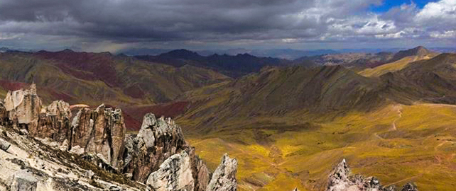
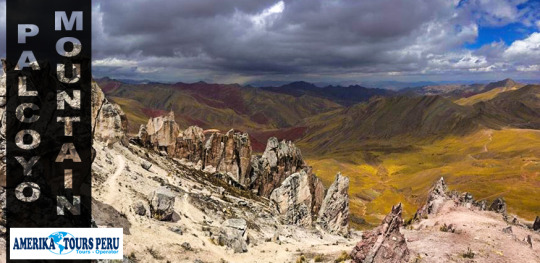
Mountain of the Seven Colors of Palccoyo: weather, hours and tips
What is the weather like in the Mountain of the Seven Colors in Palccoyo?
Palccoyo Mountain has a cold climate due to its proximity to the snowy Ausangate. The temperature can drop below 0ºC. That is why, at some times of the year, the slopes are covered in snow.
What to see in the Palccoyo mountain?
In addition to being a natural attraction of incomparable beauty, the Mountain of the Seven Colors is the natural habitat of various types of animals such as llamas, alpacas, vizcachas, condors and more.
On the route that connects Cerro Colorado there is a forest of stones formed naturally millions of years ago. From there you can closely appreciate the beauty of the snowy Ausangate, the largest in Cusco.
What is the entry time?
Due to the cold weather, visits to the Seven Colors Mountain in Palccoyo are only in the morning and part of the afternoon. Hours of operation are 8 a.m. at 3 p.m.
When is the best time to visit the mountain?
The best time to visit the Mountain of the Seven Colors in Palccoyo is during the dry season (April to October). In those months, rains occur much less frequently, making the excursion easy.
Tips for traveling to the Mountain of the Seven Colors of Palccoyo
It is recommended to acclimatize to the climate of Cusco before visiting the Palccoyo Mountain. Otherwise, the visitor may suffer from the so-called altitude sickness.
This mountain is a tourist attraction that receives few visitors every day. It is recommended to follow the indicated route and avoid looking for a different path.
It is advisable to find out how the weather is in Palccoyo before booking a tour to the Mountain of the 7 Colors. The cold can cause the entire venue to be covered in snow and ruin the tour.
The trekking route up to this mountain is not as challenging as Vinicunca. That is why the Palccoyo is a great option for people who do not feel capable of doing the difficult trek to the 7 Colors Mountain.
Enviar comentarios
Historial
Guardadas
Comunidad
7 Colors Mountain Tour – This picturesque summit used to be an attractive 4 day trek to the snowy Ausangate. Over the years, this mountain gained popularity on its own. Today, the most widespread way to visit this summit is through a tour. There are 1-day and 2-day services. Most include transportation, food, entrance fees and professional guide. In the city of Cuzco there are many tourism agencies offering these services.
Traveling on your own? – It is also possible to visit the ‘Cerro Colorado’ on your own. For this, the visitor must take a bus to Sicuani from the city of Cuzco (2 hours and 40 minutes away). Once there, a bus is taken to the town of Quesiuno. Then a walk begins (you can also hire a horse ride) to the Mountain of the 7 Colors. The price of the entrance ticket is 10 soles.
Difficulty of the mountain – The 3 or 4 hour walk (depending on the tourist’s physical condition) is not dangerous and requires moderate-high physical effort. There are considerable sections of slopes up and down. However, one of the biggest difficulties is cold weather and icy wind. The altitude of the area can cause altitude sickness or soroche. A previous acclimatization of 1 or 2 days in the city of Cusco is recommended.
Recommendations – Spend a day or two acclimatizing in the city of Cusco. Take warm clothes to do the walk. If you do not consider yourself in good physical condition for the trek, rent a horse to one of the locals. On that day, don’t forget a hat or cap, sunscreen, jacket, pants, ideal shoes for trekking and a rain poncho. MORE INFORMATION OF RAINBOW MOUNTAIN
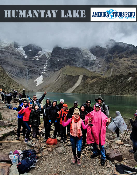
The Trek to the Humantay lagoon
Can I go to the lagoon on my own?
– Yes. To go to the lagoon on your own you must take public transportation from the city of Cusco to the town of Soraypampa. The buses leave from the ‘Arcopata’ terminal and cost approximately 15 Peruvian soles (5 USD).
Once in Soraypampa you must get a collective taxi service to the Soraypampa community. There are times when you will not find this transport so you must get a taxi. This service could cost 50 Peruvian soles (15 USD).
Finally, in Soraypampa you must make the walk to the Humantay lagoon. Due to the complexity of the trip by public transport, it is recommended to choose a tourist package with transport included. It can be cheaper and safer than going on your own.
How much does the entrance to the lagoon cost?
– In the town of Mollepata you must pay to enter the Soraypampa camp where the lagoon is. The cost for foreign tourists is 10 Peruvian soles (3 USD). The cost for Peruvian tourists is 5 Peruvian soles (2 USD). Some tour packages include this entry while others do not.
How long does the walk last?
– The final section of the trip is the walk from Soraypampa to the Humantay lagoon. This section is approximately 2 kilometers long and can take from 1 to 2 hours, depending on the physical condition of the visitor. Tourists who are not used to this type of hiking can rent a horse as transportation to the lagoon. It is common for tourists to feel the symptoms of altitude sickness, whether in Cusco, Machu Picchu or Humantay.
How to rent a horse? How much?
– The residents of the Soraypampa community offer horse rental at the starting point of the trek to the Humantay lagoon. The service is only for the upstream section and has an approximate cost of 90 Peruvian soles negotiable (30 USD).
What kind of clothes to wear?
– Due to the cold climate of the Humantay lagoon, it is recommended to wear a warm jacket as well as gloves and chullo. Of course, during the walk wear light clothing since the visitor will inevitably perspire. A rain poncho is also important since it can rain at any time.
With which tourism agency to travel?
– In Cusco there are several tourism agencies that offer the 1-day tour to the Humantay lagoon. All services must include: full transportation, breakfast, lunch and tour guide service. Choose the tourism agency that meets your expectations. Remember that you can also contract the service through the website of the tourist agency.
Can I get a tour once in Cusco?
– Yes. Unlike the Inca Trail tours or the entrances to Machu Picchu, there is always availability for the tour to the Humantay lagoon. Therefore, you can get a tour to the lagoon once in Cusco, without any problem. MORE INFORMATION OF HUMANTAY LAKE
Waqrapukara is a new tourist attraction that remains almost unknown until today. The tour is suitable for those seeking a spirituality that is drowned in the sea of commercial tours. Waqrapukara is a pre-Inca archaeological complex located in the Acomayo province within the Cusco region, near the Apurímac River. The main construction is located on platforms, squares and a so-called «Bosque de Piedras». From its height of 4,140 meters above sea level, it offers spectacular views of the Apurímac River and the Andes.
Its name comes from Quechua, “waqra” means horn, while “pukara” means fortress. Therefore, the meaning of the name translates as a “horned fortress” given by its typical form. However, the locals also called it “Llamapukara”, as they claim that the shape does not represent horns, but ears of a lama.
It was built by the pre-Inca Qanchis culture in the period called “Auqaruna” (1,500 BC – 1,000 BC). During this period, the complex was a city called “Llaqta Pukara” and home to a leader of the Yankees. It also served as an astronomical observatory and sanctuary for the god “Teqci Pachakamaq Wiraqocha” (a creator of all created things). Subsequently, it was conquered by the Incas, who have molded the buildings to geography during the reign of Wayna Qhapaq. Then it became a first-class Inca sanctuary that symbolizes an immense political and religious power that has not yet been confused. In 2017, the complex was declared Cultural Heritage of the Nation by the Ministry of Culture of Peru.
Waqrapukara Archaeological Complex. Cultural Heritage of the Nation of 2017.
It was built by the Qinchas and later conquered by the Incas. The building is located on platforms, squares and a stone forest, it would be an Inca sanctuary. Waqrapukara has a privileged view of the Apurímac River.
Waqrapucara details
Maximum Altitude: 4,140 meters / 13,580 feet
Minimum Altitude: 3,096 meters / 10,157 feet
Duration of the walk: 6 hours
Trekking distance: 15 km / 9.3 miles
Difficulty: Moderate
Weather: Cold
Waqrapukara is the archaeological monument located in Acos, Acomayo province in Cuzco, which has been declared a National Cultural Heritage by the Vice Minister of Cultural Property. This Inca monument is located on the slopes of Mount Kenter, has a privileged view of the Apurímac River and has two groups of buildings.
The first group is located at the top, in the middle of a rocky dam, where you can see two enclosures separated by a wide central space. The enclosures have halls, ornamental niches and doors with double jambs; its architecture seems to be similar to that of other ceremonial buildings.
The second enclosure is located at the bottom, and has 8 platforms 153 meters long and 1.80 meters high, which correspond to the topography of the terrain.
Some inhabitants of Acos also call it Llamapukara; and although its origins go back to pre-Inca times, its foundations were built by the Q’anchi, and the Inca construction was built during the sovereign period of the Tahuantinsuyo Wayna Qhapaq. MORE CUSCO TOURS.
One of the most precious gifts that the Inca has given us is this suspension bridge that lies over the Apurímac River. Made from straw brava or ichu icho, this wonder is renewed year after year through a rite performed by the communities of Winch’iri, Chaupibanda, Ccollana Quehue and Perccaro. Therefore, do not miss the opportunity to cross its 28 meters long which will make you experience adrenaline to the fullest in this beautiful Inca construction. QUESHUACHACA TOUR INFORMATION:
Four Lagoons
The circuit of the four lagoons is located in the province of Acomayo, 107 km from the city of Cusco. It is made up of Pomacanchi, Acopia, Asnaqocha and Pampamarca. Among its attractions are the abundance of natural grass and fish.
Small volcano in Pabellones, Yanaoca
This small volcano, approximately 4 meters in diameter, is located in the pavilion area of the Tungasuca district, which attracts attention to visitors and locals due to its unique size as it is considered the smallest in the world.
A tradition that for the peasant communities of Huinchiri, Chaupibanda, Choccayhua and Qollana Quehue has subsisted for more than five centuries thanks to the intercession of the divinity. “If we do not build a new bridge every year, we risk provoking the wrath of the Pachamama (Mother Earth in Quechua) and the Apus (tutelary forces of nature)”, “Whether we use it or not, we are exposed to natural catastrophes that they can ruin our crops of potatoes, beans, wheat or barley, and even misfortunes such as illness or death, ”says María Quispe, a 60-year-old woman who has participated in such a mission since childhood.
Before making the weaving of the bridge, a payment is made to the land, where the Paqo or Priest, makes a cloth altar with indigenous motifs in which he deposits coca leaves, llama fetuses and food that are offered to the Pachamama, since, like any human being, they are hungry and it is the obligation of their “children” (inhabitants) to satisfy them. The Paqo says that before the renovation of the bridge, the Apus indicate to him each year what his appetite is, since his tastes evolve and we should not always pay him with the same “delicacy”, to which the Apus are also invited to implore their protection and avoid accidents during renovation.
The women stay away from the work of rebuilding the bridge, a task reserved for men. The inhabitants of the place say that the woman attracts the q’encha, Quechua voice to designate bad luck, which can lead to divine “mishaps” during certain rituals.
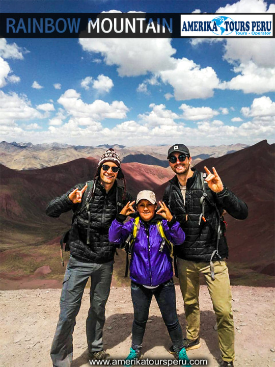
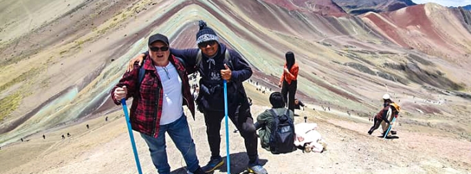
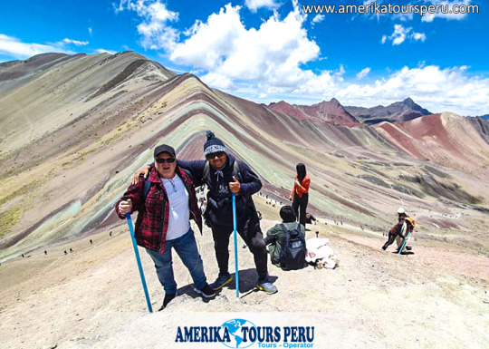
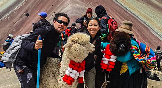
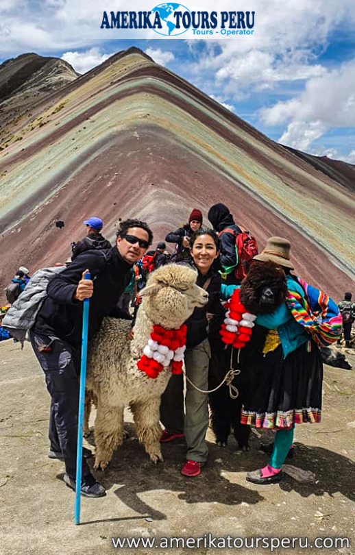
The mountain of the seven colors (VINICUNCA) is one of the most majestic attractions present on the way to the apu AUSANGATE, it is said to be a place that demonstrates a new opportunity for everyone who visits, this belief has its beginning in the saying “if you want to see the rainbow you have to face the storm” which teaches us that there is always a reward for our efforts as well as a new opportunity.
It is listed by NATIONAL GEOGRAPHIC magazine as one of the 100 places that you must visit before you die, do not miss the opportunity to be part of this wonderful place because in the end life is a wonderful adventure that begins when one really wants.
The Mountain of Colors, is also known as Rainbow Mountain, Cerro Colorado, or famously in English as Rainbow Mountain has become in recent years one of the main tourist attractions of Cusco and Peru.
This is a geographical accident belonging to the snowy Ausangate in the Vilcanota mountain range, it is the fifth mountain in Peru, it is more than 100km away from the imperial city of Cusco and it has its highest point at about 6300 masl. approx.
Its coloration is natural and this due to the large amount of sedimentary stones in erosion, what makes it so beautiful and impressive is how these stones are formed to give it the appearance of a rainbow (7 colors). The red, purple, pink, green yellow colors stand out among others.
Vinicunca (winicunca) means “mountain of colors” in Quechua (simi rune).
How to get to Rainbow Mountain
The 7 Colors Mountain is located in a small town called Pitumarca, Quipicanchis Quispicanchi province, Cusco.
To get there you must first board a car from the city of Cusco, bound for Pitumarca (approx 02 km), after 03 hrs of travel you have to take a gauge route you must reach the rural community of pampa Chiri. Then you must walk 5km towards the mountain (you can also use horses). It is recommended to bring snacks, water and energizers.
Already in this part of the road you will be able to appreciate the beauties of the valley as small lagoons, streams among others, with the passing of a short time, you will be able to appreciate how everything is changing, the colors of the Rainbow Mountain appear, thus generating a very surreal area.
Finally they will reach approx. 5033 masl which is the top of the Mountain of Seven Colors from where you can take photos and videos.
Without a doubt this is a question that many would like to clarify, thanks to the great consultation of our travelers we decided to carry out an investigation to keep them much more informed:
In order to understand how the colorful mountain was formed we must first understand how mountains are formed, for this we resort to geology and orogeny and thus have a much clearer and of course scientific idea.
The mountain ranges of the hand of their mountains are formed by collisions or collisions of different tectonic plates as these cannot advance horizontally when impacting they do it vertically forming mountain ranges and mountains and other geographic features, but this formation not only involves agents Endogenous like these collisions, but also exogenous like the vast majority of meteorological phenomena (rain, hail, snow, winds) these make the mountains maintain over time and have their particular pyramidal shape.
But Vinicunca‘s formation is much older than we think.
For this we go back in time and go back approximately 24 million years ago, back then, different layers of rock sediments such as sandstones, halites, gravels, limestone ranging from ocher, green, yellow and white along with others minerals, were compacted one on top of the other to form different layers as plasticine masses, one on top of another according to the weight of each layer; the heaviest at the bottom and the others above them.
As time passed with the movement and collision of the tectonic plates, new mountains were born, as we explained previously, these pressed colored masses rose while maintaining these typical colors.
However, the meteorological factors were in charge of preserving them and above all of keeping it in total splendor and of course respecting its typical colors equally.
And not only that, it also influences the altitude since this place is located at approximately 5000 meters above sea level. it makes the vegetation scarce to the point that almost nothing grows, if there were vegetation this great colorful wonder could not be visible.
So we add to this that not only endogenous and exogenous factors but also geographic factors such as altitude intervene.
All this is a set of curious mixtures typical of our nature because only it could give us curious landscapes that often escape from our own imagination.