inca trail

INCA TRAIL: CLASSIC ROUTE TO MACHU PICCHU

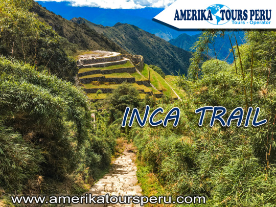
The ways of the Inca (Qhapac Ñan)

The Incas covered much of the South American continent. To maintain communication in such a vast territory, it was necessary to build a network of roads. Thus, the Inca ordered to build a network of roads called Qhapac Ñan (Inca Trail).

The Qhapac Ñan managed to cover up to 30 thousand kilometers from the current countries of Peru, Ecuador and part of Bolivia, Chile, Argentina and Colombia. The trekking route from the Inca Trail to Machu Picchu is only a small part of the extensive network of roads of the Qhapac Ñan.

The Inca Trail to Machu Picchu

The Inca Trail was revealed to the world in 1915 when it was being excavated in the Inca City. Three decades later, the route was traced by the Viking expedition in 1942. Today, thousands of visitors decide to travel the 43 kilometers to the ‘Puerta del Sol’ in Machu Picchu.

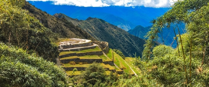
However, Machu Picchu is not the only archaeological site that you will see on the Inca Trail. On the tour you will also appreciate the ruins of Llactapata, the archaeological site of Runkurakay, Saycamarca, Phuyupatamarca and Wiñaywayna.

There are trains and buses that can take you directly to Machu Picchu. However, the experience of arriving as the Incas did for centuries is unmatched.

Versions of the Inca Trail to Machu Picchu

Not all people have the necessary days to travel the Inca Trail (4 days and 3 nights). That is why there are 2 versions depending on the time you have:

Classic Inca Trail: 4 days and 3 nights (43 kilometers of walking).

Short Inca Trail: 2 days and 1 night (12 kilometer walk).

How is the tour of the Inca Trail to Machu Picchu?

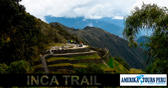
The Inca Trail shows rugged geographies with ascents and descents next to cliffs. The mountains reach great heights with rugged stretches. In the jungle areas you will see the variety of shades of green tropical forests.

Day 1: Cusco – Wayllabamba (13 kilometers)

The Inca Trail begins at kilometer 82 of the railway that leads to Machu Picchu (2 hours and 30 minutes by bus from the city of Cusco). Then the ascent to the Cusichaca valley will begin. The visitor will visit the ruins of Llactapata (2,840 masl) until reaching the town of Huayllabamba (3,057 masl).

Day 2: Wayllabamba – Pacaymayo (11 kilometers)

The second day is the most difficult due to physical demand. The tourist will ascend to the Warmiwañuska (‘Dead Woman’s Pass’). This is the highest point of the route (4,215 masl). From this point it is possible to see the Runkurakay archaeological site (3,760 masl).

Day 3: Pacaymayo – Wiñay Huayna (16 kilometers)

The third day the descent will be dizzying to the Pacaymayo river valley. The section goes down a steep slope of almost 1,600 meters to the Sayaqmarca compound (3,625 masl). Here the view is extraordinary.

Day 4: Wiñay Huayna – Machu Picchu (3 kilometers)

The last day hides some of the best Inca samples: Phuyupatamarka, Wiñaywayna. Upon leaving these ruins, a gradual descent will be undertaken which will become more complicated in the end. Finally, you will arrive at Intipunku or Puerta del Sol. From there you will walk for another 30 minutes to the Lost City of the Incas, Machu Picchu.

After visiting Machu Picchu, the visitor returns to Cusco through a train and bus service. The duration of the trip is approximately 3 hours. These services are included in the tours to the Inca Trail.

During the 4 days of the Inca Trail you will experience fatigue and very low temperatures (between the Andes Mountains and the Amazon forests).


inca trail trek

The Qhapaq Ñan: ancestral paths of the Incas

The Qhapaq Ñan, is the word that defines the road system of the Inca Civilization and is definitely the best material test, which can give us an idea of ​​the magnitude of this empire, becoming one of the greatest achievements in indigenous America. An estimated 23 thousand km is calculated, although other studies say that up to 40 thousand km could be registered, from an extensive network of roads, built on one of the most rugged territories in the world, which communicates the cities and settlements of the state most important in America, before the Spanish invasion.

This network of roads crossed the Empire of the Incas, along roads drawn from north to south (from end to end) along the coast, mountains and jungle; through the Cordillera de los Andes, with small sections, which communicated from the east of its territory to the Pacific coast. Designed in harmony with the topography of the place, wide in some areas, very narrow in others, with completely cobbled sections and others simply of land.

Like all the important cities of the Empire, the city of Machu Picchu, connected to Cusco (capital of the Empire), through the Inca Trail that we have traveled so far, at least two important accesses to the Sacred City (Inca Trail and Camino Salkantay), although there may be two others; one that descended through the Urubamba valley from Ollantaytambo, and another that crossed the high part of the Andes. And together with these, a complex network of secondary roads, to communicate the existing settlements throughout the region.

The world-famous Inca Trail to Machu Picchu, is only part of this complex network of roads, which goes up the Urubamba River basin to the Inca City, named for being the most suitable name. At present it is considered by many, the most beautiful of all, for the complement present between its landscapes and its history, you can visit it in three or four days, on a perfectly planned tour.

This Inca Trail to Machu Picchu, allowed to join production sites, with storage and administration centers. It is located in the middle of the jungle, which provides adequate environmental conditions for the production of specific foods. It is very likely that the entire Empire was supplied from this area. Therefore, this road articulated Machu Picchu with the capital and this with the other cities.

The gigantic network of roads of the Inca empire (Qhapaq Ñan) was built with the main purpose, to keep a huge territory communicated, this allowed to mobilize armies very quickly for the time. But it had other very important uses, as it served as trade routes, acting as an economic articulator, in a civilization with a tendency to redistribution and exchange, in the same way that Machu Picchu’s corn or coca reached Huánuco, In Huánuco, surplus production (potatoes and others) was redistributed in other locations, such as Machu Picchu. Another extremely important purpose was the representation of the central power of the empire, as it was thought ideologically; -Yes, I know Cusco because I have seen the road- Then, the road was the essential ideological representation of the power of the Empire, both economic and ideological.

This path, a means of communication and transport par excellence, fundamental in economic articulation and ideological dissemination, was essential for the existence of such a vast territory. It crossed the central squares of the main towns of the Empire, joining places of worship, commerce and administration, passing through water sources, an element (fundamental for life) that symbolized the goodness of Mother Earth and the reproduction of life.

And despite the information available, the Inca Trail is only a small branch of the Empire’s road network, an important tourist attraction in Peru and one of the largest in the world. Although the fact in itself, of knowing new places, what we offer is fantastic, goes beyond a visit to the Machu Picchu Sanctuary in Peru; We offer an approach to the culture of the people who built those places, to the people who currently inhabit those places, their customs and their history. So you can transform visible material evidence into an experiential learning experience.